

How to take A Grid Reference
Grid references are a way of accurately giving a location. In the UK we use the British National Grid (BNG) which covers the entire UK. BNG allows us to give our location anywhere we may be.
Grid references are used for a number of things. In the hills common uses include:
Giving your location to emergency services if you need assistance.
Leaving a route card - Locations you intend to visit while in the hills including where you parked & what hills you may visit etc.
What do Grid References look like?
In the hills we usually work with 6 figure grid references such as; NT 227 661 (Allermuir Hill, Pentlands). This gives us a 100m square of accuracy, which in emergency location is a very small area to search. These are easy to find on the hill at this accuracy using our map and compass.
There are more accurate measures such as GPS watches which can go to 10 figure grid references. For hill purposes being able to make one yourself and not having to rely on technology in case it fails, the 6 figure is accurate enough.
How do I take a grid reference?
A few simple steps listed below using your map & compass should give you your grid reference.
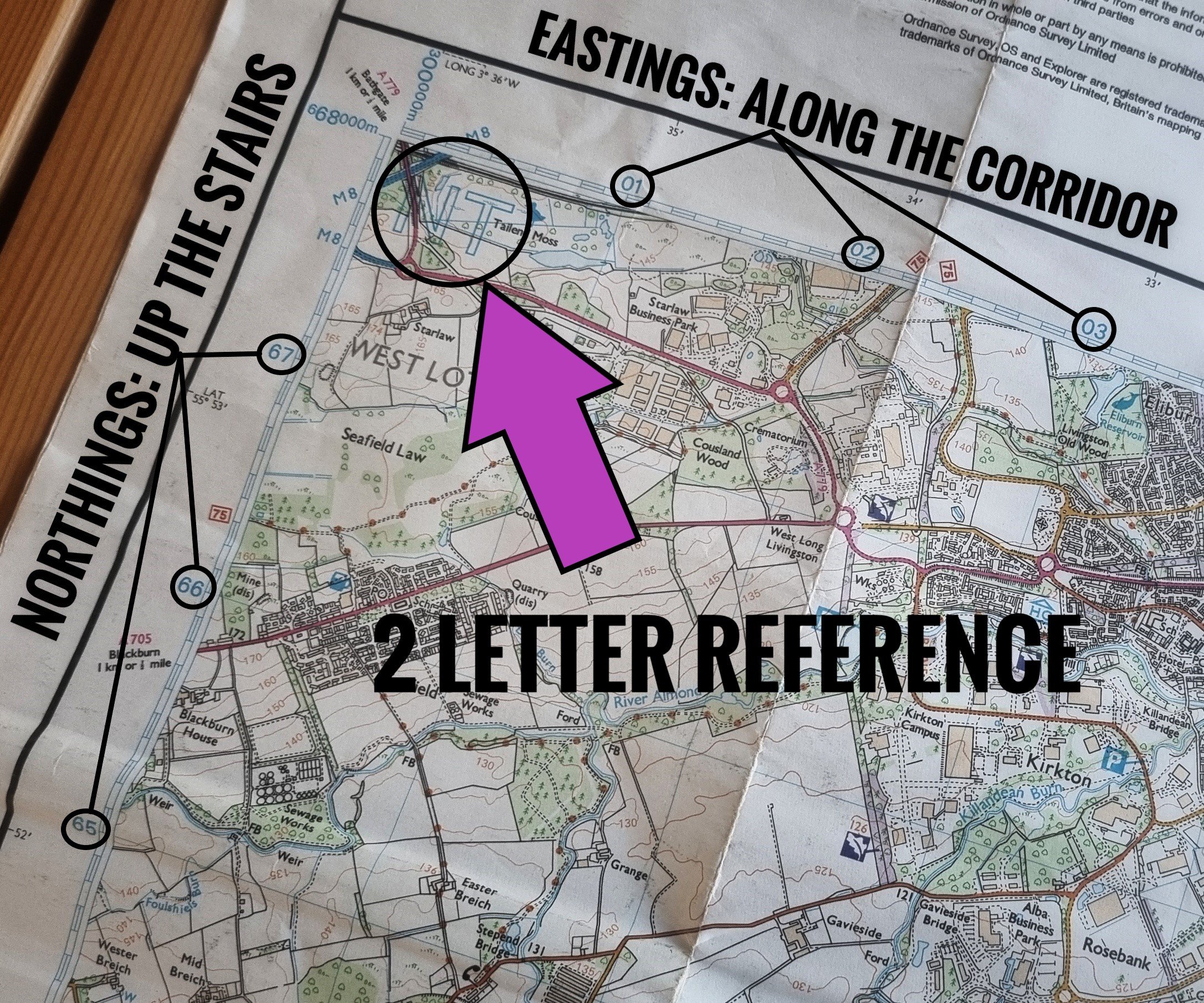
Grid references as mentioned use the British National Grid which is the blue lines that cut our maps into 1 kilometer squares. These are numbered 0-99 along the map sides. As well as this, the whole country is split into 100km squares each with a unique reference. This is shown as 2 letters usually in the top corner of your map. For instance the squares with Edinburgh & The Pentland Hills in is NT (see image below) and the majority of London is TQ.
Taking a grid reference: (I will use Allermuir Hill as the example through out - NT 227 661)
Find the 2 letter reference in this case NT (see pic 1) that makes up the beginning of our grid reference. These are individual to the 100km square you are in. Usually top right corner of your map or if you have printed the map this can be in the corners as part of full grid references.
Find the numbered part of our grid reference. Using the numbers on the blue grid lines working left to right (Eastings) and then bottom to top (Northings), we find the numbers for our point we are making the grid reference for. For this example these are; 22 (Eastings) & 66 (Northings)
A good way to remember the order is: “Along the Corridor & up the stairs”
These initial 4 numbers can be used as grid reference but only accurate to the 1km square box. If this is an emergency situation it is a lot of area to search.
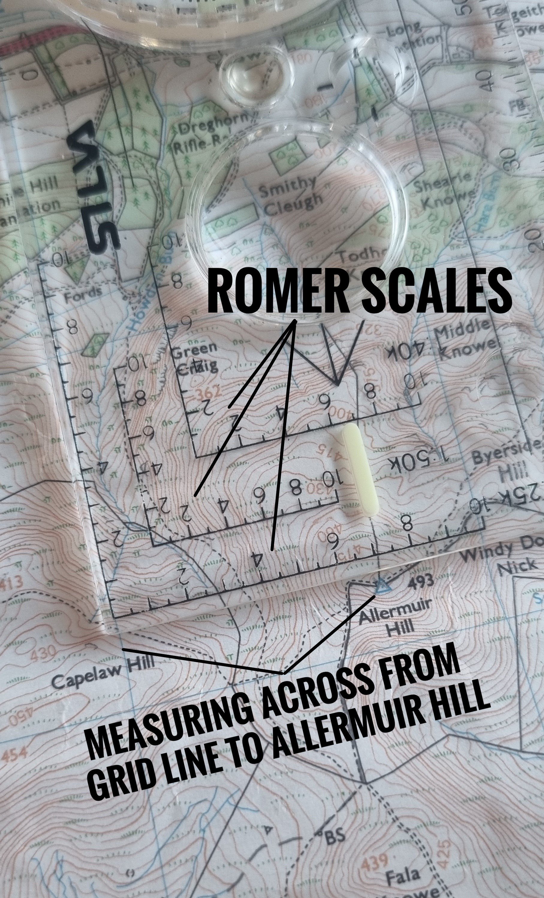
Now we have our grid square reference NT2266, we can increase the accuracy on both our Eastings & Northings.
To do this we can use the Romer Scale on our compass (see pic 2). These are numbered lines usually in the corner of the compass. They are often in a variety of standard scales; 1:25k, 1:40k & 1:50k. (see pic 2)
For this we need to use the correct Romer Scale - the same scale as your map (I.e. on a 1:25k map use the 1:25k romer scale).
Measure from the blue line of your grid square, in the picture this is “22” Eastings line across to the point you are taking the grid reference for; the blue triangle showing the summit of Allermuir Hill. For this example this is 7 (see pic 3). It is 1 7th of the way across the square.
Do this for both Eastings and Northings (left to right & bottom to Top) on your grid.
Ta da…
This should leave us with a reference in the form of NT227661 for Allermuir Hill.
NT - 100km square reference
227 - Eastings
661 - Northings
When making our grid reference, it is useful to remember we are in one number box until the point we hit the next line, then it changes. No mathematical rounding up.
What if I forget how to take a grid reference in an emergency?
Picture 1
Picture 2

Picture 3
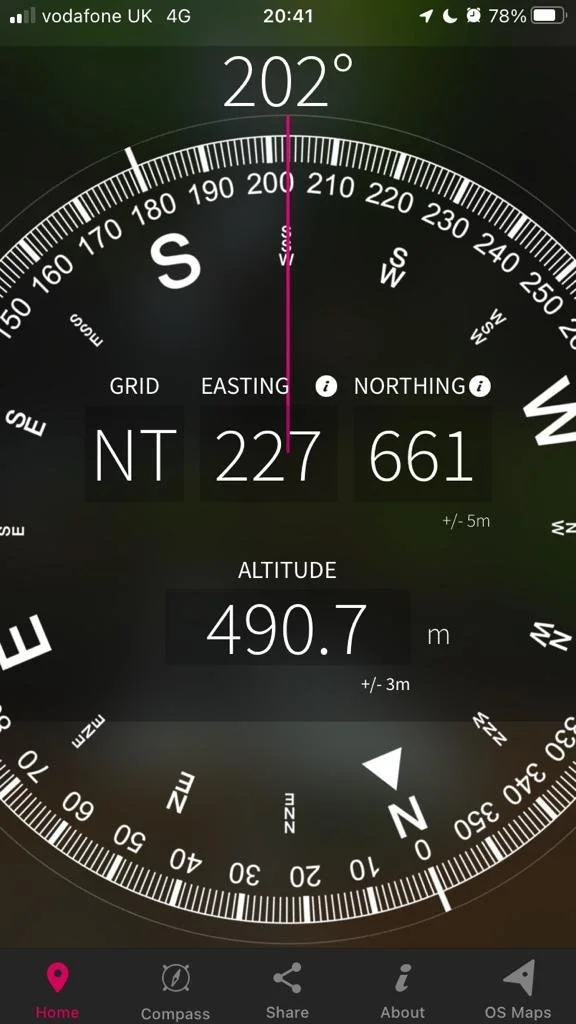
OS Locate Screen Shot - Grid Reference shown in the center
Before you head to the hills it is worth downloading OS Locate. It is a free app designed to convert GPS location readings from your mobile phone into British Grid references that you can then use in an emergency to pass on your location. [See our 999 Text Service page].
Check out Ordnance Survey’s OS Locate download link here
What about What 3 Words?
There have been numerous reports lately of Mountain Rescue Teams across the UK being sent to the wrong locations when What 3 Words has been used in an emergency. It appears some of the issue is giving the information over the phone, where things such as spellings of words, plurals of words, regional accents and also wind making it harder to understand the call have meant teams turning up in incorrect locations delaying help.
With a grid reference, the operator has a lot less room for error in receiving the information so we highly recommend using a grid reference over the what 3 words app. However, we would still prefer you to have What 3 Words rather than nothing as it certainly has worked in lots of cases as well.
Still unsure of how to take a grid reference? Check out our Beginner Navigation Courses in which we cover emergency procedures and grid references.